-
Call Now
1800-102-2727


Soil Profile, Practice Problems and FAQs
Playing with soil was kind of fun when we were kids. But our parents never allowed us to play with the soil. Do you know the reason for this? It is because billions of microorganisms are present in the soil, which may affect our health if it goes inside our body. Can you tell me why these microbes are living in the soil? One reason is that they are responsible for the degradation of materials on the soil and it also provides nutrients to the plants.
Is this the same soil which you can see in front of your house and the sea shore? Unless your house is not near the sea, the soil will be different. You have seen paddy fields. Is the soil of a paddy field the same as that of the seashore? It will be absolutely different right? So there are different types of soil based on the properties like colour, texture, moisture etc.
Fig: Different types of soils

This difference we are seeing in soil from the top layer of the Earth. Is this the same when we dig the Earth and observe? It will not be the same. We can see different layers of soil when we dig through the Earth. This is because of the different environmental conditions at different layers. In simple words these layers of soil can be called the soil profile. ‘Soil profile is considered as the vertical section of the soil from the ground surface downwards to where the soil meets the underlying rock.’ So how many such layers can be present in the soil profile and how does each layer differ? Are these layers same or different in different geographic zones? We have many questions to answer now. For this let's understand more about the soil profile in detail in this article.
Table of contents
- Components of an ecosystem
- Soil
- Soil profile
- Soil profile in different biomes
- Soil moisture
- Soil texture
- Practice Problems
- FAQs
Components of an ecosystem
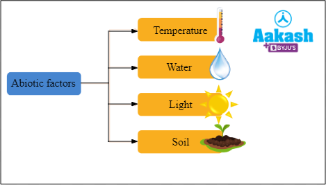
The two components of an ecosystem are the biotic and abiotic factors. While biotic factors refer to all living organisms, abiotic factors refer to the physical environment of a living organism. The major abiotic factors are the temperature, water, light and soil.
Fig: Abiotic factors
Soil
A mixture of organic matter, gases, minerals, liquids and organisms together forms the soil and it supports life.
Causes of soil formation
Nature and properties of soil vary in different places. This depends on the process of soil development. The nature and property of the soil depends mainly on the weathering process of the rocks, climate and how the soil is formed.
Fig: Causes of soil formation

Conditions required for the formation of soil
The rocks in the mountain break with different environmental conditions like sunlight, rain, heavy winds etc., and gradually soil forms.
Fig: Conditions for the formation of soil

Major characteristics of the soil
Based on the difference in this process, we see different types of soil in different areas. We can find soils with different texture, colour and composition. The characteristics of the soil vary widely. Some have gravel, their composition varies and some are in the form of aggregates or sometimes soil appears to be loose etc.
Fig: Major characteristics of the soil

Soil profile
If we observe the cross section of a well developed soil, it will show more or less distinct layers. These layers are called horizons. The thickness, colour, texture, acidity, porosity and composition of the horizons differ. Soil profile is the sequence of the horizons from the surface to the downwards. Hence the percentage of soil that spreads out vertically from the ground surface to the underlying rock can be defined as the soil profile.
Horizons of soil profile
There are several horizons or soil layers in a typical soil profile, which contains different types of soils like topsoil, subsoil and parent rock. The different horizons are as follows:
- O - horizon
- A - horizon
- B - horizon
- C - horizon
- D - horizon
Among these horizons only A-horizon and B-horizon are representing the true soil or solum. The solum and O - horizon are together called the topsoil.
Fig: Different horizons in the soil profile

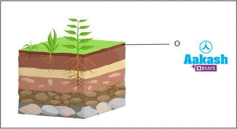
O - horizon
The topmost layer of organic matter which lies above the true soil is called O - horizon. This is the layer where the vegetation grows. This layer is made up of organic elements, tiny pebbles, twigs, surface organisms, rotting leaves and trees that have fallen. The colour of the O - soil horizon is dark brown or blue back. This is because of the abundance of organic matter. There are two subdivisions for the O - horizon and they are A00 or O1 and A0 or O2.
A00 or O1
It is the topmost layer of all the horizons, which has the freshly fallen leaves and organic debris. These materials can be still intact or partially decomposed. This layer is well developed in forests.
A0 or O2
Organic matter present in this layer is of various stages of decomposition. The upper portion of this layer contains detritus, which is the organic material in the initial stages of decomposition like dead plant parts and animal remains. The lower layer has chaff, which has fairly decomposed matter that include the scaly, dry protective casing of the cereal grains or similar materials of plants.
Fig: O - horizon of the soil profile
A - horizon
The uppermost horizon of the soil is called A - horizon. It is also called topsoil. The major constituents of this layer are the humus layer and the mineral matter. The humus layer contains a lot of organic material. It contains plenty of water and air, hence the topsoil is soft and porous. This is a fertile layer of the soil, where the seed germination, development of root, biological activities of the microbes and subterranean animals etc., occurs. The texture of this layer is light and spongy or airy. It is a dark coloured layer where the fungus, earthworm, bacteria and other microbes live. There are three sub horizons in the A - horizon. They are A1 subhorizon, A2 subhorizon and A3 subhorizon.
A1 subhorizon
The dark coloured subhorizon with more minerals mixed with humus is the A1 subhorizon. This layer is more thick in grasslands and less thick in forests.
A2 subhorizon
The light coloured subhorizon of A1 horizon is the A2 subhorizon. It has low minerals and humus. This layer is called the subhorizon of eluviation, because maximum leaching or eluviation is happening in this zone.
A3 subhorizon
The transitional layer between the A and B horizon is the A3 subhorizon. It is a light coloured compact layer.
Fig: A - horizon of the soil profile

B - horizon
The layer immediately below the A - horizon and above the bedrock is called B - horizon. It is described as the subsoil. This layer is rich in minerals and clay, more dense or dark coloured, coarse textured and more compact. But it has less organic matter, soluble materials and humus, when compared to other layers of the soil. It is also called the zone of illuviation. B - horizon is compact, hard and has poor aeration because of the illuviation. Frequent mixing of A and B horizons happens while ploughing. There are three layers in the B horizons. They are layers B1, B2 and B3.
Layer B1
This layer is a transitional layer of the A - horizon to the B - horizon. Hence it is more similar to the A - horizon.
Layer B2
It is a dark colured layer which contains a maximum amount of leached material that has been transported downward by the gravitational water.
Layer B3
This layer is composed of large chunks of parent rock material.
Fig: B - horizon of the soil profile

C - horizon
This layer is made up of irregular rock fragments that are incompletely weathered and it is devoid of biological stuff. It is also called saprolite. This horizon is nearly saturated with moisture.
Fig: C - horizon of the soil profile

D - horizon
The base of the soil profile is called D - horizon. It is composed of the unweathered parent rock, which is called the bedrock.
Fig: D - horizon of the soil profile

Apart from all these layers, there are two more layers called the E - horizon and R - horizon.
E - horizon
The layer where the nutrients from the O - horizon and A - horizon washed down is called the E - horizon. This region will contain less clay, hence it is mostly seen in the forests.
Fig: E - horizon of the soil profile

R - horizon
The complex and complicated coating made of cement is called R - horizon. It is composed of rocks like granite, limestone, basalt etc.
Fig: R - horizon of the soil profile

Soil profile in different biomes
The soil profile differs according to the biomes. The variations can occur in different aspects such as the depth of the soil, depth of the horizons, concentration of organic matter and minerals, amount of clay and colour. Now let’s check out the soil profile in different biomes like deserts, grasslands, tropical forests, and temperate forests.
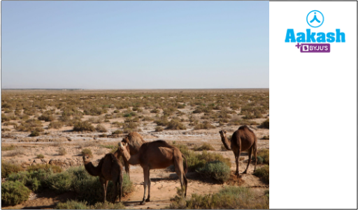
Desert soil
O - horizon and humus are absent in the desert soil. Clay, sand, minerals and salts are present in the subsoil.
Fig: Desert
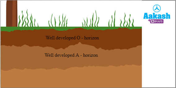
Grassland soil
In grassland soil, the O - horizon is well developed. Every year, a large amount of organic matter is added to the grassland soil. It also has a well developed A - horizon. Roots of the plants will form a tangled mass or sod by penetrating deep into the soil. This sod can prevent soil erosion and also hold the moisture in the soil.
Fig: Soil profile of grassland
Tropical rainforest soil
Due to leaching, the topsoil of the tropical forest is poor in mineral nutrients and very little humus is present. The O - horizon of this soil is thin, hence the litter does not stay for so long. Leaching makes the A - horizon more shallow and light pink in colour. The B - horizon of this soil is comparatively deep and the sublayers are not well differentiated. Dense clay mixed with iron - aluminium compounds are the components of a B - horizon. Rotting happens in the lower region of the soil profile.
Fig: Soil profile of tropical rainforest

Temperate deciduous forest soil
Due to slow decomposition of organic matter, there is a well developed O - horizon and it is dark brown in colour. Various types of mineral components are present in the topsoil. The A - horizon is dark in colour and deep. It is rich in humus. The B - horizon is rich in clay and has loam. The sublayers of B - horizon are well differentiated. Loam and silt is present in the upper layer of the B - horizon, but in the lower region it is full of dark-brown clay. The origin of oil in the temperate deciduous forest is glacial.
Fig: Soil profile of temperate deciduous forest

Soil moisture
Now we know that a soil profile is composed of minerals, rocks, clay and different layers of soil, but along with this another important factor in a soil profile or the soil formation is the water content in the soil. This is referred to as the soil moisture.
The water is distributed on the surface of the soil during precipitation. Then the downward movement of water happens and this movement depends on the size of the particles and porous nature of the soil. Until it reaches the saturation point, the penetration of the water continues deep into the soil. After that the water cannot move vertically, so it will move in sideways. As a result of saturation, puddles are formed and it is called surface ponding. This can be long lasting too.
Fig: Puddles

Types of soil moisture
There are two types of soil moisture depending on their availability and they are as follows:
- Surface soil moisture – The water available in the immediate upper region of the soil.
- Root zone moisture – The water available to plants.
Tensiometer
Tensiometer is the device used for the measurement of the moisture content in the soil. These are water filled tubes that are sealed with a porous ceramic tip at the bottom. At the top of this there is a gauge which is vacuum or devoid of air molecules. This device is penetrated into the soil till the root level. Water moves from the tube to the soil until it reaches an equilibrium. As a result a tension is created and it is recorded in the gauge. The readings on the gauge is the measure of the soil moisture in that particular area.
Fig: Electronic tensiometer

Types of soil moisture
There are different types of water present in the soil and they are as follows:
- Gravitational water
- Hygroscopic water
- Chemically combined water
- Capillary water
- Atmospheric humidity
Gravitational water
It is the water reaching the water table of the soil. The upper surface of the zone of saturation is called the water table. This happens due to the presence of gravitational force, hence called gravitational water. This water is usually not available to plants. It is present in the macropores of the soil.
GIF: Gravitational water

Hygroscopic water
The thin film of water which is soaked from the atmosphere to the soil and held tightly by the soil particles is called hygroscopic water. It is also not available to plants.

Fig: Hygroscopic water
Chemically combined water
Once the hygroscopic water is removed, then the remaining water combines with chemicals and turns into chemicals like hydrated oxides of iron, silicon etc. this is due to the heat of the soil. This water is called combined water or chemically combined water. This is also not available to the plants.
Capillary water
After the free flow of water on the soil gets drained out, there will be some remaining water and it is called capillary water. This water is existing between the soil particles in small capillaries. This water can be absorbed by the plants.
GIF: Capillary water
Atmospheric humidity
The air in the atmosphere carries a certain amount of water in the form of vapour. Epiphytes have hygroscopic hairs which are used for absorbing the atmospheric moisture.
Importance of soil moisture
Soil moisture is important for the growth of plants and since plants are the primary producers, it will affect the life of all other organisms. Importance of soil moisture are as follows:
- Soil water contains nutrients, hence it is a source of nutrients for plants.
- Moisture content in the soil of a particular area can determine the yield of a crop.
- The warmth of the soil is maintained by the soil moisture.
- The development of soil can be controlled by the soil moisture
- Plants like rice need water for their survival, hence the soil with the most moisture content is perfect for it.
- Soil moisture can catalyse the biological activities of microorganisms.
- Water is necessary for the photosynthesis to take place and soil moisture helps in photosynthesis.
Soil texture
The texture of the soil is another factor that supports the soil profile. Soil texture is defined as the relative proportion of silt, sand, and clay sized particles that make up the soil. It is one of the important physical properties of the soil. Several physicochemical properties of soil like density, capillary and non-capillary pore spaces, water holding capacity, aeration, temperature etc., are affected by the soil texture. Penetration of roots of plants also depends on the texture of the soil.
Types of soil particles
The size of the soil particle determines the texture of the soil. The soil particles can be divided into three categories on the basis of their size or average particle diameter and they are as follows:
- Sand (2 – 0.05 mm)
- Silt (0.05 – 0.002 mm)
- Clay (less than 0.00 2mm)
Fig: Types of soil particles

Loam soil
The name of the texture of the soil is given by the name of the dominant fraction of the soil particle. If a soil has all the three fractions such as sand, clay and silt in approximately equal proportions, then the soil is called a loam soil.
Fig: Loam soil

Soil textural triangle
There are 12 different types or textural classes of soil on the basis of different combinations of the four fractions such as sand, slit, clay and loam. Soil textural triangle is the one which depicts the 12 textural classes and the percentages of sand, silt and clay fractions that are included in each.
Fig: Soil textural triangle
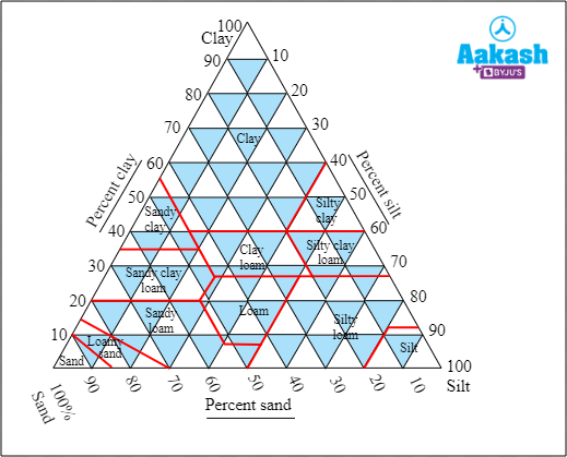
Analysis of the soil texture triangle
The three sides of the soil textural triangle represent 0 to 100% of sand, silt and clay respectively. The percentage lines for clay run parallel to the baseline of sand, the percentage lines of silt run parallel to the baseline of the clay and percentage lines of sand run parallel to the silt side of the triangle. In reading the textural triangle, any two particle fractions will locate the textural class at the point where these two intersect. This is one method to find out the texture of a soil sample.
Experiment to find out the soil texture using sieve set
This is an experiment to find out the texture of a soil sample by using a sieve set and the soil texture triangle. For this experiment, we have to collect about 300 to 500 grams of soil from two different locations. Now label the soil samples as sample A and sample B and then dry the samples using an oven, stove or under the sun. This is to remove the soil moisture.
Next select the three sieves of different sizes and arrange them in a collecting chamber as shown in the image below. The pores of each sieve will be similar to the size of the three soil particles (sand, silt and clay). The next step is to place the 200 gm of soil sample A in the first sieve. Now shake the sieve set manually after closing the lid. After shaking it for 5 to 10 minutes, collect the three fractions of the soil.

Fig: Sieve set
After this process the sand, slit and clay will be separated in different compartments of the sieve set. Now collect each sample and weigh it. The total weight of the three samples should be equal to the weight of the soil sample (200 gms). After this calculate the percentages of various soil fractions such as sand, silt and clay. Now by using the soil textural triangle, the textural class of the soil can be found out. The same procedure is done for sample B.
Calculation of soil fractions
We took a 200 gms soil sample and got the following weights for each fraction of the soil in sample A from the experiment.
Weight of sand = 140 gm
Weight of sand in percentage = 140/200 X 100 = 70%
Weight of silt = 20 gm
Weight of silt in percentage = 20/200 X 100 = 10%
Weight of clay = 40 gm
Weight of clay in percentage = 40/200 X 100 = 20%
The weights of each fraction of the soil in sample B are as follows:
Weight of sand = 30 gm
Weight of sand in percentage = 30/200 X 100 = 15%
Weight of silt = 10 gm
Weight of silt in percentage = 10/200 X 100 = 5%
Weight of clay = 160 gm
Weight of clay in percentage = 160/200 X 100 = 80%
The percentage of each of the soil fractions
The percentage of each of the soil fractions in sample A and B are tabulated below:
Fig: The percentage of each of the soil fractions

Calculation using soil texture triangle
If we get the percentage for each fractions then the next step is to read the soil texture triangle. For that we need to know which line depicts each of the fractions. We have already discussed that, to draw a line for sand, we have to find the points parallel to the silt. In the same way, the line of silt is parallel to the clay and the line of the clay is parallel to the sand.
If we draw the three lines inside the triangle, then there will be a point of intersection of the three lines. This point describes the type of the soil. So to find out the type of the soil, we have to consider the red lines inside the triangle and inside which loop of the red lines, the point has come. Now we can easily find out the texture of the soil.
So for sample A if we draw the three lines for three fractions, it will be joining at a point where the sandy loam has marked. Hence sample A is a sandy loam.
Fig: Soil textural triangle for sample A

For sample B if we draw the three lines for three fractions, it will be joining at a point where the clay has marked. Hence sample B is considered as clay.
Fig: Soil textural triangle for sample B

Through the soil textural triangle, the type of soil has been found out. Now we know that, if the percentage of the fractions of particles present in the soil is known, then it is easy to find out the texture of the soil.
Fig: Conclusion of the experiment

Practice Problems
1. Given below are some statements about the O - horizon of a soil profile. Find out the correct statements?
I) It is the topmost layer of organic matter which lies above the true soil.
II) It is the layer where the growth of vegetation happens.
III) The colour is dark brown or blue black.
IV) There are three subdivisions in the O - horizon.
V) A0 is the topmost layer of all the horizons.
- I, II, III, IV, V
- I, II, III
- IV and V
- I, II, III, V
Solution: Soil profile is the sequence of the horizons from the surface to the downwards. There are several horizons or soil layers in a typical soil profile, which contains different types of soils like topsoil, subsoil and parent rock. The topmost layer of organic matter which lies above the true soil is called O - horizon. This is the layer where the vegetation grows. This layer is made up of organic elements, tiny pebbles, twigs and surface organisms like rotting leaves and trees that have fallen. The colour of the O - soil horizon is dark brown or blue back. This is because of the abundance of organic matter. There are two subdivisions for the O - horizon and they are A00 or O1 and A0 or O2. A00 or O1 is the topmost layer of all the horizons, which has the freshly fallen leaves and organic debris. These materials can be still intact or partially decomposed. This layer is well developed in forests. Hence the correct option is b.
Fig: O - horizon of the soil profile

2. Which of the following are not correctly matched?
- A1 subhorizon - More thick in grasslands and less thick in forests.
- Layer B2 - Maximum amount of leached material that has been transported downward by the gravitational water.
- D - horizon - Composed of the unweathered parent rock.
- E - horizon - Composed of rocks like granites, limestones, basalts etc.
- A, B, C, D
- A, B, C
- A and D
- E only
Solution: There are several horizons or soil layers in a typical soil profile, which contains different types of soils like topsoil, subsoil and parent rock. The different horizons are O - horizon, A - horizon, B - horizon, C - horizon and D - horizon. Apart from all these layers, there are two more layers called the E - horizon and R - horizon. The uppermost horizon of the soil is called A - horizon. It is also called topsoil. There are three sub horizons for A - horizon. They are A1 subhorizon, A2 subhorizon, A3 subhorizon. The dark coloured subhorizon with more minerals mixed with humus is the A1 subhorizon. This layer is more thick in grasslands and less thick in forests. The layer immediately below the A - horizon and above the bedrock is called B - horizon. It is described as the subsoil. There are three layers in the B horizons. These are layers B1, B2 and B3. Layer B2 is a dark colured layer which contains a maximum amount of leached material that has been transported downward by the gravitational water. The base of the soil profile is called D - horizon. It is composed of the unweathered parent rock, which is called bedrock. The layer where the nutrients from the O - horizon and A - horizon washed down is called E - horizon. This region will contain less clay, hence it is mostly seen in the forests. The complex and complicated coating made of cement is called R - horizon. It is composed of rocks like granites, limestones, basalts etc. Hence the correct option is d.
Fig: Different horizons in the soil profile

3. Which of the following soil moisture or water is available for plants?
- Gravitational water
- Hygroscopic water
- Chemically combined water
- Capillary water
Solution: The water content in the soil is referred to as soil moisture. There are different types of soil moisture or water present in the soil and they are gravitational water, hygroscopic water, chemically combined water, capillary water and atmospheric humidity. Gravitational water is the water reaching the water table of the soil. This happens due to the presence of gravitational force, hence called gravitational water. This water is usually not available to plants. It is present in the macropores of the soil. The thin film of water which is soaked from the atmosphere to the soil and held tightly by the soil particles is called hygroscopic water. It is also not available to plants. If the hygroscopic water is removed, then the remaining water combines with chemicals and forms hydrated oxides of iron, silicon etc. This occurs due to the heat of the soil. This water is called combined water or chemically combined water. This is also not available to the plants. After the free flow of water on the soil gets drained out, there will be some remaining water and it is called capillary water. This water is existing between the soil particles in small capillaries. This water can be absorbed by the plants. Hence the correct option is d.
GIF: Capillary water
4. If a 300 gm of soil sample has 30 gm sand, 170 gm silt and 100 gm clay. What is the texture of the soil?
- Silty clay loam
- Loamy sand
- Clay loam
- Sandy clay
Solution: Given that the amount of soil fractions are 30 gm of sand, 170 gm of silt, 100 gm of clay and the total amount of soil is 300 gm. So the percentage of each of the soil fractions are as follows: 10 % of sand, 56.6 % of silt and 33.33 % of clay. By comparing these percentages in the soil texture triangle we can find out the texture of the soil. The name of the texture of the soil is given by the name of the dominant fraction of the soil particle. If a soil has all the three fractions in approximately equal proportions, then the soil is called a loam soil. There are 12 different types or textural classes of soil on the basis of different combinations of the four fractions; sand, slit, clay and loam. Soil textural triangle is the one which depicts the 12 textural classes and the percentages of sand, silt and clay fractions that are included in each. The three sides of the textural triangle represent 0 to 100% of sand, silt and clay respectively. The percentage lines for clay run parallel to the baseline of sand, the percentage lines of silt run parallel to the baseline of the clay and percentage lines of sand run parallel to the silt side of the triangle. So if we draw three lines representing the three functions of the soil, it will intersect in the silty clay loam. Hence the correct option is a.
Fig: Soil textural triangle

FAQs
1. What is the pH of soil?
Answer: The pH of soil ranges from 3.5 to 10. If there is high rainfall in an area, then the pH ranges from 5 to 7, but in dry areas, it is 6.5 to 9. The pH of neutral soil ranges from 6.5 to 7.5.
2. Which type of soil is best for crop production?
Answer: Loamy soil is best for crop production, because it is a mixture of sand, silt and clay which can hold more water than the normal soil. A good amount of nutrients and humus are also present in the loamy soil which are essential for the growth of plants.
3. How does water content differ in different soils?
Answer: Clay soil contains small and fine particles which can hold more amount of water. Medium sized particles are present in the loamy soil, hence it retains moderate amounts of water. Sand contains less nutritional content and large particles and as a result, less amount of water is retained in the sand.
4. What makes the soil red?
Answer: High percentage of iron content in the soil makes it red. But this soil is deficient in other elements like nitrogen and magnesium. It also has less phosphoric acid and lime. It is fairly rich with potash and the pH ranges from neutral to acidic.
YOUTUBE LINK: https://www.youtube.com/watch?v=wRIiD8kwVbM
https://www.youtube.com/watch?v=f3_JPuAkRZ0
https://www.youtube.com/watch?v=0aDaNGhusN8
Related Topics
|
Soil Erosion , Practice Problems and FAQs |
|
Decomposition, Process of decomposition, Factors affecting decomposition, Practice Problems and FAQs |
|
Minerals, Practice Problems and FAQs |