
What is GPS?
GPS stands for Global Positioning System. It is a widely used navigation system that provides precise location and timing information to users worldwide. The GPS system consists of a network of satellites, ground-based control stations, and receivers. Developed and maintained by the United States Department of Defense (DoD), GPS was initially designed for military purposes but has since become an indispensable tool for civilian applications as well.
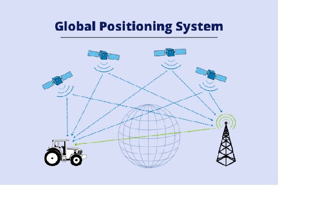
The primary purpose of GPS is to determine the exact geographic coordinates of a particular location anywhere on Earth. The system utilizes a constellation of satellites that orbit the Earth at fixed positions, transmitting signals that can be picked up by GPS receivers. These receivers, commonly found in smartphones, navigation devices, and other electronic devices, then calculate the user’s precise position based on the signals received from multiple satellites.
The GPS satellites constantly broadcast signals containing information about their positions and the precise time at which the signals were transmitted. By receiving signals from multiple satellites simultaneously, a GPS receiver can determine the distance between itself and each satellite based on the time it takes for the signals to reach the receiver. Using a technique called trilateration, the receiver can then compute its precise three-dimensional position, including latitude, longitude, and altitude.
In addition to providing accurate positioning information, GPS also offers precise timing synchronization. The GPS system relies on highly accurate atomic clocks on board the satellites, which transmit their time information along with the positioning data. This feature has proven crucial for various applications, including telecommunications, financial transactions, scientific research, and transportation systems.
GPS has a wide range of applications across various sectors. In the realm of transportation, GPS has revolutionized navigation, enabling drivers to receive turn-by-turn directions, real-time traffic updates, and accurate estimated arrival times. It has also played a significant role in logistics, fleet management, and emergency services by enabling efficient routing and tracking of vehicles.
Moreover, GPS is extensively used in outdoor recreational activities such as hiking, biking, and geocaching, allowing enthusiasts to navigate unfamiliar terrains with ease and precision. It has also become an integral part of fitness devices, helping individuals track their workouts and measure performance metrics like distance and pace.
Furthermore, GPS has found its way into agriculture, where it aids in precision farming techniques by facilitating accurate mapping, crop monitoring, and yield optimization. It also plays a crucial role in surveying and mapping, supporting cartographers, land surveyors, and construction professionals in their work.
In conclusion, GPS (Global Positioning System) is a remarkable technology that has transformed the way we navigate and position ourselves on Earth. Its ability to provide accurate and reliable positioning information has led to countless applications in various industries, making it an indispensable tool in today’s interconnected world.
Full Form List
| OBC Full Form | EVS Full Form |
| OTT Full Form | IG Full Form |
| DM Full Form | JEE Full Form |
| CMO Full Form | EOD Full Form |
| MMS Full Form | NASA Full Form |
FAQs
GPS receivers calculate your precise location by receiving signals from multiple satellites and using a technique called trilateration. The receiver measures the distance between itself and each satellite based on the time it takes for the signals to reach the receiver. By intersecting the distance measurements from multiple satellites, the receiver can determine your three-dimensional position (latitude, longitude, and altitude). The GPS system consists of a constellation of approximately 30 satellites orbiting the Earth at an altitude of about 20,000 kilometers. These satellites are strategically positioned to ensure global coverage and accurate positioning information. GPS signals can be weakened or blocked by obstructions such as tall buildings, dense foliage, or indoor environments. In such cases, the accuracy of the GPS positioning may be compromised or the signals may be lost altogether. However, advancements in technology have led to the development of assisted GPS (A-GPS) and other techniques that can enhance GPS performance in challenging environments. While GPS is widely known for its navigation and mapping capabilities, its applications extend far beyond that. GPS is used in various industries and sectors, including aviation, agriculture, telecommunications, emergency services, surveying, construction, and fitness, among others. It provides precise timing synchronization, facilitates efficient fleet management, aids in precision farming techniques, and supports scientific research, among many other applications. Yes, GPS is a free service provided by the United States government. The satellite signals transmitted by the GPS system are accessible to anyone with a GPS receiver. However, it's important to note that there may be costs associated with acquiring a GPS receiver or accessing GPS-based services provided by third-party applications or devices.How does GPS determine my exact location?
How many satellites are part of the GPS system?
Can GPS work indoors or in urban environments with tall buildings?
Is GPS limited to navigation and mapping applications only?
Is GPS a free service available to everyone?